Semliki River
The Semliki River is a 143-mile (230-km) waterway located in the Western Rift Valley that connects Lake Edward to Lake Albert.
What is Semliki River?
The Semliki River is a 143-mile (230-km) waterway located in the Western Rift Valley that connects Lake Edward to Lake Albert.1
Originating at the northwestern end of Lake Edward in the Democratic Republic of the Congo, the river flows north-northeast along the western base of the Ruwenzori Range. During the latter portion of its journey, the river serves as a natural border between the Congo and Uganda.1
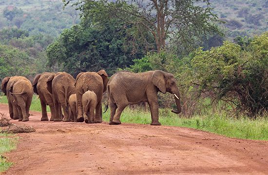
The river is notable for its significant alluvial plain, which supports a diverse array of wildlife, including elephants, hippopotamuses, crocodiles, and various antelope species. A portion of this area is protected within the Virunga National Park. At its mouth, the river’s delta is densely populated with papyrus and ambatch trees, and it is actively expanding into Lake Albert.1
What is the significance of the Ruwenzori Range?
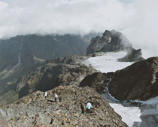
The Ruwenzori Range is a mountain group of significant geographical and historical importance located on the border between Uganda and the Democratic Republic of the Congo.
Historical and Geographical Significance
The range is widely believed to be the legendary “Mountains of the Moon” described by the 2nd-century geographer Ptolemy and was long sought as the fabled source of the Nile. Unlike many other major African peaks, the Ruwenzori is not of volcanic origin; it is a massive horst consisting of six distinct glaciated massifs, including Mount Stanley, which features Margherita Peak, the range’s highest point at 16,795 feet (5,119 meters).23
Economic and Ecological Value
- Resources: The range is economically vital due to its copper and cobalt deposits, mined at Kilembe, Uganda, with hydropower for these operations supplied by the Mubuku River.2
- Conservation: The Ruwenzori Mountains National Park, a UNESCO World Heritage site, protects this unique alpine environment and its relict glaciers.34
- Agriculture: The lower eastern slopes support local communities, such as the Konjo people, who cultivate essential crops like bananas and sweet potatoes.2
How does the Western Rift Valley influence the region’s geography?
The Western Rift Valley is a major branch of the East African Rift System that profoundly shapes the region’s geography through tectonic activity and the creation of distinct landscapes.67
Tectonic and Physical Features
The valley is characterized by its deep, fjordlike lakes, including Lake Tanganyika, Lake Kivu, Lake Edward, and Lake Albert. These basins were formed by the downward collapse of crustal blocks between diverging plates, resulting in steep escarpments and dramatic elevation changes. Unlike the Eastern Rift, the Western Rift generally lacks extensive volcanic activity, with the notable exception of the Virunga Mountains, where periodic eruptions have significantly altered local drainage patterns, such as the creation of Lake Kivu.6289
Influence on Drainage and Relief
The valley acts as a major structural control for regional hydrology:
- Drainage Divides: The Virunga Mountains serve as a critical divide between the Nile River and Congo River drainage systems.9
- Alluvial Landscapes: The rift’s steep walls and tectonic activity have created unique environments, such as the alluvial plains and deltas found at the mouths of rivers like the Semliki River.109
- Horsts: The region also features massive horsts, such as the Ruwenzori Range, which stand as non-volcanic mountain blocks elevated by the same tectonic tensions that created the surrounding rift.108
What makes Virunga National Park important for wildlife conservation?
Virunga National Park, established in 1925 in the Democratic Republic of the Congo, is a site of immense ecological importance due to its vast diversity of habitats and unique wildlife populations. Designated as a UNESCO World Heritage site in 1979, the park encompasses a wide range of environments, including savannas, marshes, peat bogs, lava plains, and tropical rainforests, as well as the cloud forests of the Virunga Mountains.1112
The park is particularly significant for the conservation of several key species, most notably the rare mountain gorilla.11 It also serves as a critical habitat for elephants, lions, hippopotamuses, okapis, and various antelope and pelican species.-mammal) and pelican species. Despite its biological richness, the park faces significant challenges, including poaching, deforestation, and the impact of human settlements, which have led to its inclusion on the List of World Heritage in Danger.1211
Sources
- Semliki River — Encyclopædia Britannica
- Ruwenzori Range — Encyclopædia Britannica
- Ruwenzori — Merriam-Webster
- East African mountains - Physiography — Encyclopædia Britannica
- Uganda - Conservation — Encyclopædia Britannica
- East African Rift System — Encyclopædia Britannica
- Africa - Relief — Encyclopædia Britannica
- tectonic basins and rift valleys - Rift valleys — Encyclopædia Britannica
- Western Rift Valley — Encyclopædia Britannica
- East African lakes - Physiography — Encyclopædia Britannica
- Virunga National Park — Encyclopædia Britannica
- Goma: Top Questions — Encyclopædia Britannica
- Virunga Mountains — Encyclopædia Britannica
Published on · 3 min read